
The 2+ versions of Rigas Charta
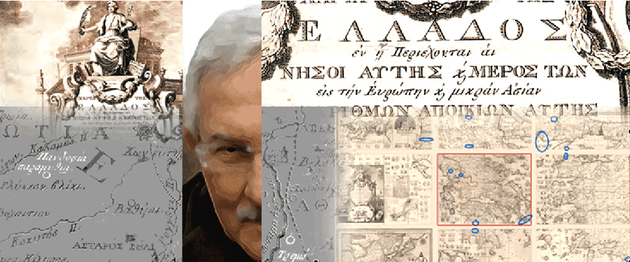
Rigas Velestinlis [w(fr)] [w] the emblematic personality of Modern Greek Enlightenment [w] published his 12-sheet map (ca 2x2 m), known as Charta of Greece in Vienna, in Greek language, the years 1796 (one sheet, the No. 1) and 1797 (eleven sheets, the Nos. 2 to 12). This map considered as …chef-d’oeuvre d’érudition et de patience... by an anonym in the Magasin Pittoresque, Paris 1861, vol. XIX, p. 191, is placed on the top of importance of maps printed in Greek language from the late 18th to the early 19th centuries (see the Catalogue by G. Tolias). Since the years of Charta's publication (1796-1797) there was no indication or reference whatsoever on the existance of more than one versions of Charta. In 2008 E. Livieratos discovered the existance of 2 versions of Rigas Charta and in 2010 a version's variant
About the map
Here are reported the rather few non-Greek language references relevant to Rigas Charta: C. Nicolopoulo 1824, "Notice sur la vie de Rhigas", Paris; J.-H. A. Ubicini 1881, "La Grande Carte par Rhigas", Revue de Géographie, Paris; E. M. Edmonds 1890, Rhigas Pheraios, London; E. Legrand 1892, Documents inédits concernant Righas Velestinlis et ses compagnons de martyre, Paris; A. Dascalakis 1937, "Les oeuvres de Rhigas Velestinlis", Thèse, Paris; C. M. Woodhouse 1995, Rhigas Velestinlis: The Proto-martyr of the Greek Revolution, Denise Harvey; J.-Y. Guiomar et M.-T. Lorain 2006, "La carte de Grèce de Rigas et le nom de la Grèce", Annales historiques de la Révolution française, No. 319, en ligne le: 11 mai 2006 > ; G. Tolias 2008, "Antiquarianism, Patriotism and Empire. Transfer of the cartography of the Travels of Anacharsis the Younger, 1788-1811", e-Perimetron, Vol. 3, No. 3, 101-119; E. Livieratos 2008, "On the cartography of Rigas Charta", e-Perimetron, Vol. 3, No. 3, 120-145; C. Boutoura 2008, "On the map projection of Rigas Velestinlis Charta", e-Perimetron, Vol. 3, No. 3, 146-160
The discovery
In September 2008, preparing the 10th Hellenic Cartographic Conference (Ioannina, November 2008) and a map exhibition dedicated to the Rigas Charta, two copies of this map were already available in digital form: the copy from the Aristotle University Library (AUTH - Thessaloniki) and the copy from the Sylvia Ioannou Map Collection (Athens). The idea was to use the two copies for presentation at the exhibition of the area around the city of Ioannina, a centre of scholarship in the times of Rigas, depicted in two maps from two map-collections, one in coloured form (the AUTH copy) and the other in monochromatic form (the Ioannou copy); see the following image
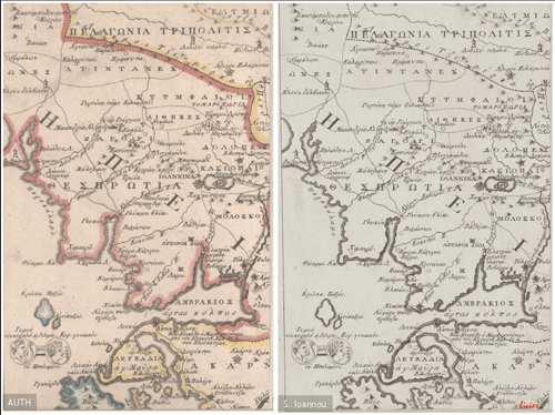
Elaborating the two images digitally it came out that the two copies belong to two different versions of the Rigas Charta, something totally unknown for 211 years (1797-2008)
The digital approach used
Following the process of the comparative analysis of the two maps in digital-form (see E. Livieratos 2006, "On the study of the geometric properties of historical cartographic representations", Cartographica, Vol. 41, No. 2, 165-175; C. Boutoura, E. Livieratos 2006, "Some fundamentals for the study of the geometry of early maps by comparative methods", e-Perimetron, Vol. 1, No. 1, 60-70), and applying optimal-fitting methods, plus the digital, negative-positive, transparency technique, as introduced by E. Livieratos, 2006, in the comparison process following optimal fittings, (see the "The use of animation in visualizing deformations of a portolan-type map", e-Perimetron, Vol. 1, No. 1, 71-76; also M. Daniil 2006, "Comparing by digital transparency the differences between two almost identical 17th century map of North Aegean", e-Perimetron, Vol. 1, No. 4, 287-286) it came out the striking result shown in the following synthetic image, composed by the overlapping of two optimally fitted images, obeying the digital-image-processing property of transparency, one in greyscale-positive mode (the Ioannou copy) and the other in the greyscale-negative mode (the AUTH copy):
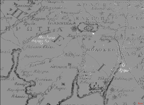
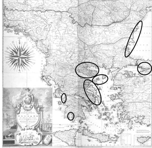
The result of the process, was the emergence of two more toponyms (the white place names in the image above) clearly seen in the composite image. Obviously, the additional toponyms exist in the AUTH copy but not in the Ioannou copy. The unexpected fortunate result, an outcome of pure scientific curiosity, after the first shock of the discovery, led to the organization of a meticulous work for the digital comparision of the whole area of the map (4 sq. m. large) which unveiled the "secret" of a 211 years old map: the existance of two versions of Rigas Charta! Thirteen differences were detected (four on sheet No. 5), all additions on the version represented by the AUTH copy, missing from the version represented by the Ioannou copy, as it is shown in the following image:
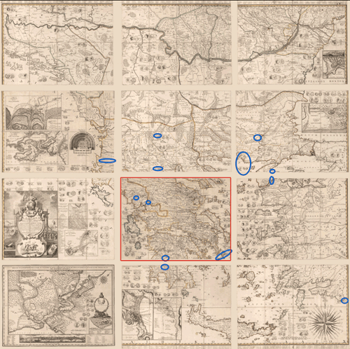 The numbering of the twelve map-sheets starts from the bottom row sheets (left No. 1, middle No. 2, right No. 3) continuing upwards
Expanding the research to other available copies in Greece and abroad (UK, France, Sweden, with the kind feedback of map-librarians at institutions like the BL-British Library and the RGS-Royal Geographical Society in London, the BnF-Bibliothèque nationale de France in Paris and the KB-National Library in Stockholm) it was soon concluded that the copies of Rigas Charta should be included in two stereotype categories, the Version-A (the copies without additions) and the Version-B (the copies with the additions). The impressive discovery was documented and published for the first time in October 4, 2008 in E. Livieratos' academic website and soon later in the note: E. Livieratos 2008, "On the unveiling of two versions of Rigas Velestinlis Charta", e-Perimetron, Vol. 3, No.3, 183-190
Further findings
The research in this challenging domain of Rigas Charta continued since then, offering further findings like e.g. the existence of variants in the two main Charta versions; see the note: E. Livieratos 2010, "A variant of Rigas Velestinlis Version-A Charta: The Kapesovo copy", e-Perimetron, Vol. 5, No., 103-106. Relevant research is carried out in the frame of a doctoral dissertation (M. Pazarli) prepared at the School of Rural and Surveying Engineering, AUTH (defended in March 2014)
High quality digitisation
Three copies of the Rigas Charta kept in Greece were kindly digitised by the CCG - Colour Consulting Group. CCG has generously offered and implemented high quality scanning to the copies of the Kozani Municipal Library, the Sylvia Ioannou Collection and the Kapesovo Paschaleios School Collection
 The Kozani and the Kapesovo copies of Rigas Charta digitised in the Colour Consulting Group of Thessaloniki. From left: Angeliki Tsorlini (AUTH), Thomas Raptis (Kapesovo), Ioanna Stergiopoulou (Kozani), Evangelos Livieratos (AUTH), Dimos Granis (CCG)
Affine - Anthimos Gazis
In the context of the research on Rigas Charta, relevant studies are carried out concerning an apparently similar map by the Greek cleric and scholar Anthimos Gazis [w] the "Pinax (i.e. Tabula) of Greece" published also in Vienna (1800). This map, with the half of Charta's dimensions (ca 1x1 m), was erroneously considered for centuries as just ...a copy, only reduced in size, of Rigas Charta (cf. the map-catalogue of Prince Alexander Lovanov of Rostov published in Paris, 1823) or, even worse, as having the Pinax ...the same dimesions of Charta, the latter looking larger because of the addition of a number of topographic plans on it...! (cf. Ch. Reichard 1808, in Allgemeine Geographische Ephemeriden, XXX, 323-331). The cfs. above, concerning the erroneous reference of Pinax as a Charta's copy, are given in footnotes 5 and 6, p. 33 in E. Livieratos 2009, Hagion Oros kai Kypros ston khartē tēs Elladas tou Anthimou Gazē (1800), I. M. Simonos Petras: Agioreitiki Vivliothēkē (el), transl. "Mount Athos and Cyprus in the Anthimos Gazis' Map of Greece (1800)", H.M. Simon Petras: Mount Athos Library. Our recent research proved, by using the comparative digital optimal-fitting methods, that the Gazis map stands for its own, since it is a different map, in many aspects of the geometric and thematic map content, despite the apparent similarity with Charta; see the following image for some of the most evident differences with Charta; more
More on Anthimos Gazis Pinax in: E. Livieratos 2008, "O Pinax tou Anthimou Gazē", Map Exhibition Bifoliate, Ē Kozanē ston kosmo tōn khartōn