Ptolemy
In the European West, the impact of Claudius Ptolemy's [w] [w(fr)] Geographia [w] [w(fr)] in cartography starts actually in the late 14th - early 15th cent., after its transfer to Florence, the translation in Latin and its broad diffusion especially throughout the 16th cent.
Basics
The most important cartography-related issues introduced by Ptolemy with his Geographia are:
- The listing of ca 7,000 places of the known-World at the time, each assigned a name and a pair of spherical coordinates, the longitude from the Fortunate Islands and the latitude from the Equator
- The grouping of these places within the three known continents i.e. Europe, Asia and Africa: each group of places is set in hierarchically organised and explicitly named geographical areas, all then embedded in an anonymous but numbered master-area, with well-geoferenced framing, the so called Table (Pinax/Tabula, alias a Map). So, for every continent C (e.g. Europe) a group of i in multitude places (i=1,2,3,...) belongs to a named geographic area Y (e.g. Macedonia) within the geospatially defined frame of a numbered (I/1st, II/2nd, III/3rd, IVth,....) Table/Map (e.g. the X/10th Table)
- The numerical-geographical content of Geographia with the rest of material included is practically an Atlas, the first ever presented in the history of cartography
- The guidelines given for the technical construction of world maps, using the place-coordinates and the system of the projection, including the three well-known Ptolemy projections i.e. the conic or first-projection (I-Pp), the curvilinear or the second-projection (II-Pp) and the perspective or the third-projection (III-Pp)
- The guidelines given for the technical construction of the trapezoidal projection (t-Pp) for the cartographic representation of the content of Tables as defined above
See Ptolemy+
Projections
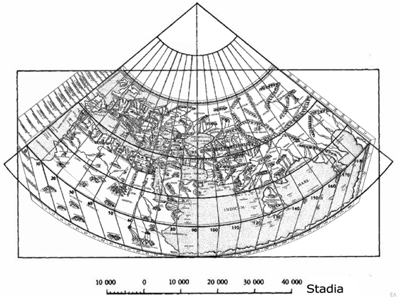
The most known and easy to handle Ptolemy's map-projection is the I-Pp. Because of its theoretical clarity and straightforward constructural facility the I-Pp is the most popular of Prolemy's three projections together with the t-Pp used for representing the content of Tables in map-form
|
| The world map on Rome's 1490 edition of Ptolemy's Geographia in the I-Pp |
The II-Pp, although better simulating visually the spherical shape of the earth, it is very sophisticated in its definition and complicated for implementation, requiring advanced skills and experience. Both I-Pp and II-Pp have been used in the Renaissance, the second especially for the construction of the highly artistic world-maps of the period
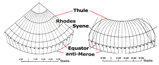 |
| I-Pp (left) and II-Pp (right) with reference parallels |
The III-Pp is the less used projection in common cartographic productions. Nevertheless, its implicit impact in the geometric-artistic thinking of the Renaissance is of great importance since it contributed in the experimental and later in the theoretical foundation of perspectivity in the Grand-painting and architecture. The concept of III-Pp is also behind the principles of the oblique map-projections suitable for our contemporary space-mapping
Tabulae/Maps+density
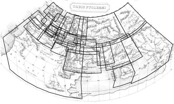
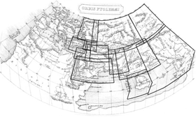
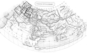
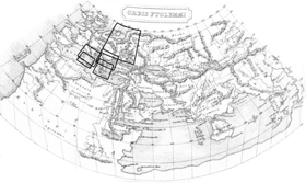
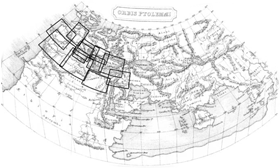
Mostly used in the cartographic implementation of Ptolemy's Geographia is the t-Pp, because of its easy and convenient applicability in constructing the maps of the areas represented in the Tables/Maps. Twenty-six Tables in total, cover the known World at that time in the three continents Europe, Asia and Africa. The dimensions of an area covered by a certain Table is inversely proportional to the number of georeferenced places available in the relevant Geographia's list:
- The fewer are the available georeferenced places in a Table the larger are the dimensions of the corresponding Table-area with respect to the earth-surface. Contrary, the more are the available georeferenced places in a Table the smaller are the dimensions of the corresponding Table-area with respect to the earth-surface.
- Given the previous inverse analogies, it is cartographically obvious that the scale of map-representation of the Table contents should be smaller in the first case and larger in the second one
|
 |
 |
 |
The above inverse proportionality relating the number of the available georeferenced places in a Table with the dimensions of the Table representations with respect to the earth-surface and its relevant scale can be clearly seen in the above images of cartographic representations of the Table-coverage of Europe, Asia and Africa. It is obvious that the Tables containing few georeferenced places (i.e. scarse density, as it is mostly in Asia and Africa) cover large areas on the ground whilst the contrary holds for Tables with larger numbers of georeferenced places (i.e. high density mostly in Europe)
High density - larger scale
From Geographia's twenty-six Tables/Maps in total, only nine (ca 35%) contain a higher number of georeferenced places, thus a high density of georeferenced information: five in Europe, three in Asia and one in Africa. These nine Tables, with the relevant geographical regions, cover smaller ground areas with larger cartographic scale representation:
Europe
- V Table: Rhaetiae Situs, Vindeliciae situs, Pannoniae situs, Inferioris Pannoniae situs, Illyridis aut Liburnuae seu Dalmatiae situs
- VI Table: Italiae situs, Curni Insulae situs
- VII Table: Sardiniae Insulae situs, Siciliae Insulae situs
- IX Table: Iazygum Metanastarum situs, Daciae situs, Superioris Mysiae situs, Mysiae Inferioris situs, Thraciae situs
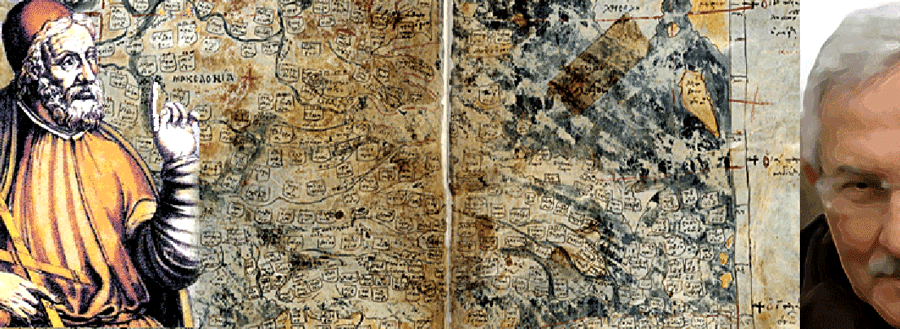
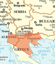
- X Table: Macedoniae situs, Epiri Descriptio, Achaiae situs, Peloponesi situs, Cretae Insulae situs
Asia
- I Table: Ponti et Bithyniae situs, Asiae Proprie dictae situs, Lysiae situs, Galatiae situs, Pamphyliae situs, Cappadociae situs, Armeniae Minoris situs, Ciliciae situs
- III Table: Colchidis situs, Iberiae situs, Albaniae descriptio, Armeniae Maioris situs
- IV Table: Cypri situs, Syriae descriptio, Palestinae Iudeae, Arabiae Petreae situs, Mesopotamiae situs, Arabiae Desertae situs, Babiloniae situs
Africa
- III Table: Cyrenes situs, Marmaricae Libyae et totius Aegypti descriptio
Re: Strasbourg Cartographia edition, 1513
 |
 |
 |
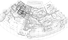
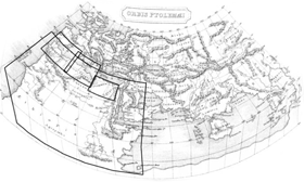
Europe's highest density
Considering the number of georeferenced places in Europe's X Table/Map, 529 in total, with respect to the small ground coverege (most of the present-day territory of Greece is represented in X Table) we conclude that the X Table contains the highest place-positioning density among the ten Tables of the European continent
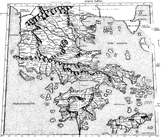
The second case in line is II Table, representing Iberia, with 514 georeferenced places but covering much more ground area than the X Table. In Asia the highest place positioning density is in I Table, with 675 georeferenced places but covering much more ground as well
Impact
The impact of Ptolemy's Geographia in the geographic and cartographic thinking of the Renaissance World was great after its translation into Latin, 1409. Especially in Florence prominant humanist scholars with strong interest for the Greek cultural legacy (i.e. Collucio Salutati, Marsili, Traversari, Niccoli, Bruni, Toscanelli, Bracciolini, Marsuppini) participate in study-sessions for the understanding, interpretation and evaluation of Geographia, probably even before its translation into Latin, in the Camaldolesi retreats of Santa Maria degli Angeli. According to P. Gautier-Dalché 2007, "The Reception of Ptolemy's Geography (End of the Fourteenth to Beginning of the Sixteenth Century)", D. Woodward, ed., History of Cartography: Cartography in the European Renaissance, Vol. 3; Chicago: University Press, one of the major outcomes of this new line of thought, thanks to Ptolemy, was the introduction in the West of the method of positioning of georeferenced places on a properly projected graticule onto a map with the aid of the coordinates (longitude - latidute)
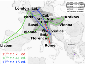 |
Seven Geographia editions printed in 15th cent. along the axis Rome-Ulm, followed by the exploit of the forty-one editions in 16th cent. all over Europe, from London to Florence and from Lisbon to Krakow. The 17th cent. fifteen editions appeared in a narrow zone extended from Leiden to Venice. In the image, the shadowed area shows the major editorial activity on Ptolemy's Geographia mainly in the central part of Europe |
On the other hand, the careful instructions given in Geographia on the techniques to follow for setting-up a map, in combination with the dissemination of typography, contributed to the development of cartography at highest levels from 16th to 18th cent. onwards
Placement of new lands
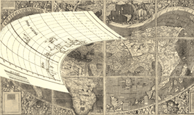
A typical example of the new cartographic culture implied in Renaissance Europe was the introduction of the positioning method with the projection of georeferenced places onto the map-plane, using coordinates. This georeference capacity associate the places discovered in the late 15th and the early 16th cent. combined now with the tracing on maps of the reference frame of meridians and parallels opening thus the way for the placement of the recently discovered new worlds in Age of Discoveries. Typical examples are the early 16th century maps, like e.g. the 1507 Waldseemüller's map [w] [w(de)] [w(fr)] representing the new continent named America thanks to the geoinformation provided by the Florentine Amerigo Vespucci [w(it)] and the other sources available to the St Dié humanist scholars
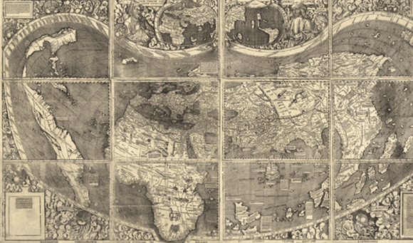 The 1507 Martin Waldseemüller's World map, placing the discovered new continent and the place-name America for the first time on a writen document whatsoever
 |
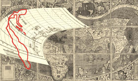 |
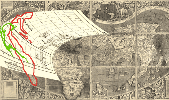 The correct positioning of the new continent (green-coastline) with respect to the Waldseemuller's positioning (red-coastline)
Legacy
The Geographia legacy continues far after the meta-Geographia era of cartography, elaborated by the new masters active in 16th cent. onwards, who in fact reformed Ptolemy's ideas and foundamental methodologies. The echos of Ptolemy's tradition can be still found in 18th century scholar cartography, e.g. in toponymy, in the division of geographic areas, recalling the Roman administrative nomenclature etc. It is very interesting to quest on such issues as well as on the recent revival of Ptolemy's Geography, revisiting the numerical part of his work by contemporary digital processes
See Ptolemy+