
HOME | CV | COURSES | RESEARCH | MAP PRODUCTION | PUBLICATIONS
Map Production
The first Land Use Map of Greece, 1987
In the 1980s, during her service in the Ministry of Environment, Prof. Boutoura was in charge with the compilation, production and the printing of the first 1:500000 Land Use map of Greece in 4 sheets (1987)
University work, 1995-
Prof. Boutoura started for the first time the map production with the use of digital cartography methods and techniques in AUTH SRSE, in the mid 1990s. Main concern was not only the digital design and implementation, but also the printing process. All maps produced since then satisfied the strict rules of cartographic science and art as a result of a systematic research work and long practical experience gained in the real world of map production, colour process and printing. Special care was taken for:
- the geometric reliability of the map base, in relation to the scale of representation,
- the geodetic reference and map projection,
- the evaluation and homogenisation of the geometric and thematic data, which are used for the map syntaxis,
- the care for the graphics, the standardisation of the composition, the symbolism, the use of colour,
- the focus on the relief and the photorealistic shading, according to the sumulated position of the Sun
The maps produced and printed so far satisfied third parties requests, e.g. orders from the National Centre for Maps and Cartographic Heritage (1997-2005) for use by the local and regional administration, public and private institutions and publishers, but also the educational needs of students on under- and postgraduate levels, in cartographic synthesis, design and production
Emphasis is given in the production of standardised map-sheets at the "1 cm to km" scale (1:100000) representing the territories of the (old) Prefectures of Greece. This project is developed, with great success, in the frame of students projects in cartographic compilation, design and production.
This long cartographic map production project was carried out with the cooperation of Prof. E. Livieratos, Dr. K. Papadopoulos, Dr. A. Tsorlini and E. Daniil. See also here
For samples of maps produced in AUTH SRSE see here
The School Atlases project, 1995-1997
The School Atlas project concerned the preparation of two School Atlases, one for Greece and one for Europe for the Thessaloniki editor Rekos, in 1996 and 1997
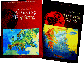
Emphasis in this new Atlases was given in the innovative design and the interaction between the student anf the teacher in the study process
