
Matteo Ricci World Map
The cartographic research on Matteo Ricci "Chinese" World Map (1602) started in 2011, focused on the geometric and projective properties of the map content. The study is also extended in the comparison with the 1604 version of the map, transliterating the phonetic Chinese characters into Japanese (due to Katakana)
The research concerns also the cartographic specific placement of the Americas in the Ricci map, in comparison to the relevant mapping standard placements in all the rest maps of the period
The research on the issue has recently refueled thanks to the Workshop on Ancient Chinese Maps and Exchange of Chinese-Western Cartographic Culture held in Beijing, 3 June 2015, at the Institute of Geographic Sciences and Natural Resources Research of the Chinese Academy of Sciences (IGSNRR), organised by the Commission of Cartography and GIS of the China Society of Surveying & Mapping and Geoinformation under the sponsorship and support of the Zhengzhou University of Information Engineering, the IGSNRR and the State key Laboratory of Resources and Environmental Information System (LREIS).
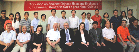
Institute of Geographic Sciences and Natural Resources Research of the Chinese Academy of Sciences, Beijing, 3 June 2015
Invited scientists from China and Europe coming from Research Institutes and Labs of the Chinese Academy of Sciences, from Universities, the National Library of China and other Institutions, presented their research on the issue and participated in discussions for future work. Academicians Gao Jun and Zhou Chenghu and Profs Qi Qingwen, Sun Qun, Liqiu Meng, Bai Hongye, Gong Yingyan, Lu Liangzhi, Liang Qizhang and Evangelos Livieratos, presented papers and participated in the closing round table discussion. The International Cartographic Association was represented by the Chair of the Commission on Digital Technologies in Cartographic Heritage (E. Livieratos), the Chair of the Commission on Theoretical Cartography (Qingyun Du) and the Vice Chair of the Commission on Atlases (Qingwen Qi)
|
A short life-trip eastwards
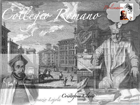
The Jesuit priest Matteo Ricci wider known for his missionary and scientific work in China, including cartography, during the late period of the Ming Dynasty, named Li Madou in Chinese (for a first introduction see [w(it)]; [w]) was born in the city of Macerata ( 1552) in the today's Italian region of Marche, under the territorial authority of the Papal States at that times. He died in Beijing at the age of 58 (1610), after leaving Europe 32 years before.
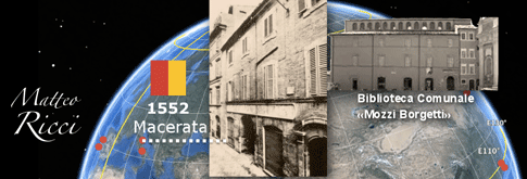 |
Matteo Ricci's house of birth in Macerata, in the Marche region of Italy and the town Municipal Library, dedicated to his legacy, where Matteo received his first education before moving to Collegio Romano in Rome, at the age of 16 |
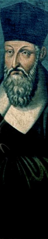
At the age of 16 he moved to Rome for studying law and three years after he participated with the Papal forces in the naval battle of Lepanto. In Rome he joined the Society of Jesus (IHS) studying finally astronomy, mathematics, geography and cartography in the Collegio Romano with Clavius the important jesuit scholar follower of Ptolemaean doctrines in astronomy and geography
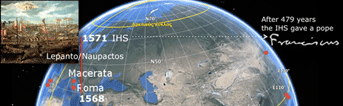 Pope Francis (1936- ) is since 2013 the first jesuit pope in history Pope Francis (1936- ) is since 2013 the first jesuit pope in history |
 |
|
Ricci's studies on geography and cartography in the Collegio Romano and relevant training for gaining skills, under Cristophorus Clavius, it was impossible not to be affected, among other scientific knowledge, by the Ptolemaean Geographia legacy which was dominant in the scholar thinking in Rome at that time, having Clavius as his teacher, a zealous follower of the Alexandrine geographer and cartographer. Besides, it was Ptolemaean cosmological and representational models the leading theoretical grounds of relevant thinking in the Roman Church scientific scholarship of that times |
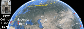
Almost ten years after staying in Rome he moved at the age of 25 to Coimbra in Portugal, the education stronghold of the jesuits preparing missions overseas and a year after to Lisbon, his last European stop before sailing East
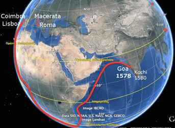 |
The six-month sea trip from Lisbon to Goa, his ordainship in Kochi and his arrival in Macau, closer to the Chinese destination |
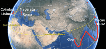
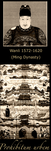
After a six-month trip following the portuguese sea line eastwards, Ricci arrived in the portuguese ruled port of Goa where he taught in jesuit schools and ordained priest in the also strategic port of Kochi (Cochin) in southern India. At the age of 30 he moved eastwards to Macau, always in portuguese territories where he was among the very first and few westerners learning Chinese, preparing himself for his definite move to China, at that time under the emperor Wanli (1572-1620) of the Ming Dynasty
 |
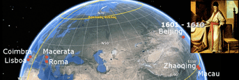 |
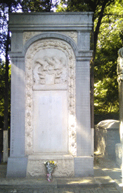
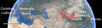
He finally established in Zhaoqing after one year of preparations in Macau. There, and in some other places in China he spent 18 years of his active life before his final move to Beijing at the age of 49. In Beijing he lived for nine more years before dying in 1610 at the age of 58.
Matteo Ricci was the first westerner allowed to visit the Forbitten City and the first who burried there. His tomb the major among the tombs of other 62 missionaries mostly foreigners is in Beijing Zhalan cemetery, a cultural relic under the protection of the Chinese state since 2006
Greek reference
Ricci's solid education in the Greek-echoed cultural and scientific environment of the Collegio Romano and the jesuit inclination to Greek philosophy finds a reasonable explanation of his concern to translate first him the Euclid's Elements in Chinese language, with the help of the prominent scholar Xu Guangqi. Ricci supported the idea that Greek philosophy is closer to Confucianism than any other western thinking, so that ancient Greek thinking was capable to open gates to Christianity in China. He based his ideas on the principles of adaptation (aptatio) and accomodation (accommodatio)
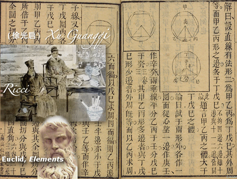 |
The first translation in Chinese of Euclid's Elements. The foundamental Greek work on Geometry |
Changing the World Map stereotype
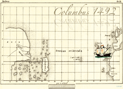
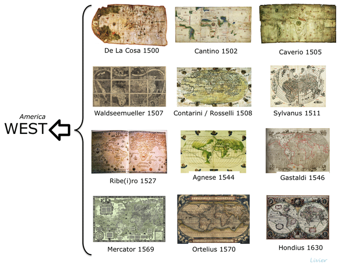
All the 16th century World Maps, after the Great Discoveries, i.e. De la Cosa (1500), Cantino (1502), Caverio (1505), Waldseemueller (1507), Contarini-Rosselli (1508), Sylvanus (1511), Ribe(i)ro 1527, Bordone (1528), Agnese (1544), Gastaldi (1546), Mercator (1569), Ortelius (1570) follow the stereotype of placing the representation of the New World westwards with respect to the Old World
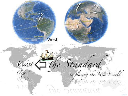 |
After the European Discoveries in the late 15th century to the West, the Old World consisted of the three ancient interconnected continents, Europe (1), Asia (2) and Africa (3), a new continent (4) is entering into the mapping picture of the World. The New World is placed in the western (left) side of the maps. This placement became soon the dominant stereotype of world cartography since the beginning of 16th century |
This placement was dominant in cartography for a century before
Ricci's World Map and after, in 17th century. The obvious driving force for this cartographic doctrine was apparently the westwards direction of Columbus' and all the other sailings after him for reaching either the Old World (Columbus) or the New World emerged on maps after Columbus
 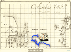 |
The heading westwards in sailing to the Old World at the end of 15th century which soon turned to be the sailing to the New World established the placement of the Americas at the west part of the maps becoming thus a standard |
 |
The Matteo Ricci 1602 World Map but also his previous "Chinese maps" change this dominant stereotype, introducing a model in which the New World is placed, for the first time eastwards. Why?
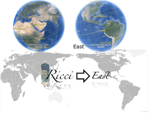 |
Matteo Ricci changes the placement of the New World stereotype: the Americas are now represented in the eastern (right) part of the map. Why? |
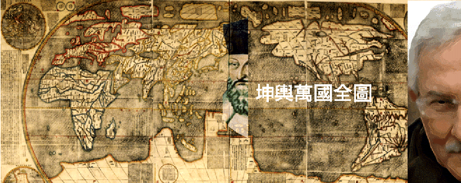
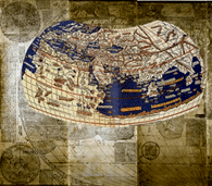
The Ricci World Map
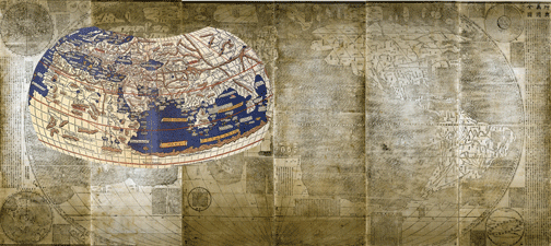
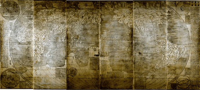 One of the few extant 1602 map version copies of the Ricci World Map: the James Ford Bell Library copy at the University of Minnesota, acquired for 1M$ and digitised by the Library of Congress. The other copies of this version are in the Vatican Apostolic Library, the ÖNB - Austrian National Library (restored and exhibited in 2011), in a private collection in France and in Japanese libraries (Kyoto University, Miyagi Prefecture, Japanese Cabinet and Tohoku University -with the transliterarion of the phonetic Chinese characters into Japanese, due to Katakana). Map title: (translated from Chinese) Complete map myriad lands of the World; dimensions: 366 cm width (longitudinal) x 152 cm height (latitudinal); sheets: six 61 cm width x 152 cm height (folded in two, 76+76 cm)
This early 17th century World Map entitled in Chinese Kunyu Wanguo Quantu (A Map of the Myriad Countries of the World or Complete Geographical Map of all the Kingdoms of the World
according to the translation in Italian). The original 1602 Ricci map was printed in several copies most now lost. Surprisingly no original prints of this very map are known to exist in China, among the only seven original copies, which are known to exist, three in good condition and kept in the Vatican Apostolic Library, in the James Ford Bell Library, University of Minnesota, in the Austrian National Library, Vienna (restored and exhibited in 2011) plus
the copies kept in Japan and in a private collection in France. Versions of the 1602 map were exported to Japan and later to Korea. The unattributed coloured edition of the map, known in Japanese as Konyo Bankoku Zenzu was made in Japan ca 1604. In this version, Japanese “Katakana” (a component of the Japanese writing system) is utilised for foreign location names throughout the western world
 |
The unattributed coloured edition of the Ricci map, known in Japanese as Konyo Bankoku Zenzu was made in Japan ca 1604. In this version, Japanese “Katakana” (a component of the Japanese writing system) is utilised for foreign location names throughout the western world. The map carries important corrections in the graticule |
The emblematic Matteo Ricci World Map in Chinese, is considered a diachronic masterpiece in the history of the Chinese cultural relations and interactions with Europe and the West in general. For an introduction see [w]
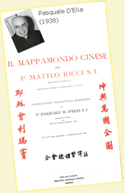 The 1602 copy kept in the Vatican Apostolic Library was reproduced by Pasquale d’Elia, Il mappamondo cinese del P Matteo Ricci, S.I. in 1938. In the d’Elia reference work are contained Italian translations of the colophons on the map, a catalogue of all toponyms with detailed notes regarding their identification.
This map is the first appeared in China in Chinese language made in the European cartographic tradition. The main characteristic of Ricci's World Map is the placement of the Americas in the east part of the map in contrast with the dominant standard placement in the west part depicted in all maps of the period
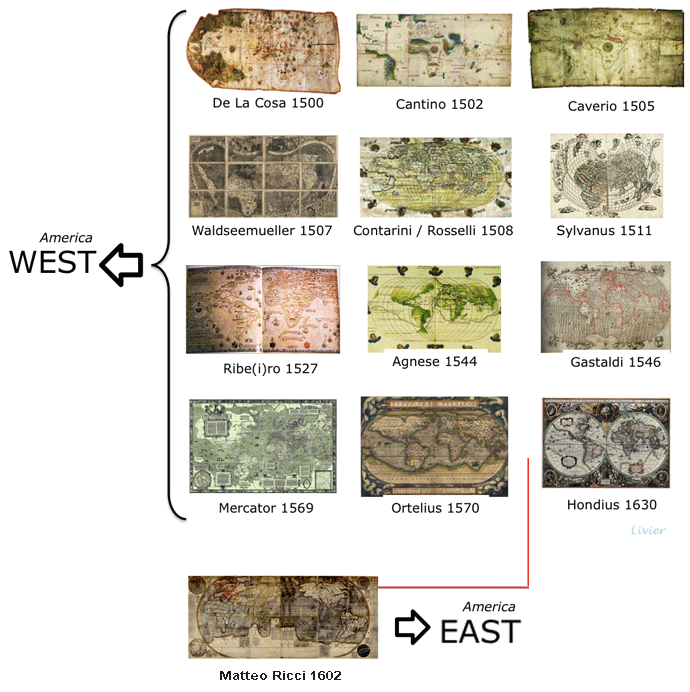 Ricci changed the westwards standard placement of the Americas in the World Maps by placing the New World eastwards. Was it a technical desicion related to expediency or the result of a specific cultural preparation?
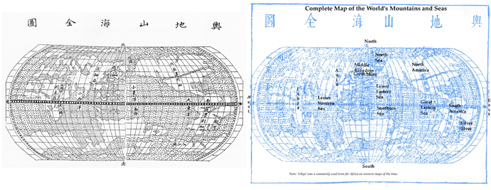
Among some earlier versions of the Ricci's World Map is the Complete Map of the World's Mountains and Rivers, following the same pattern for the placement of the Americas but a different coastline set
 |
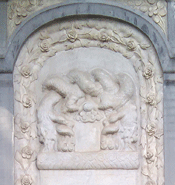
A popular variant of Ricci's 1602 version, is the colourful later manuscript map kept in Nanjing, China, with expressive depictions of animals, fishes and western type sailing ships
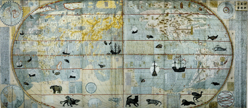 |
The later manuscript colourful version of the 1602 map, decorated with animals, fishes-cetaceans and western type sailing ships |
Why Ricci changed the stereotype?
The widely spread interpretation of the displacement by Ricci of the Americas from the stereotype position at the west part of all maps of his time to the east part in his map is attributed to the (presumable) intention of the Jesuit scholar to satisfy the Chinese Emperor and his influencing court by highlighting prominently China in the middle of the World, which was possible only by simply shifting the Americas from the west side to the east side of the map. This simplified explanation of the new model in the placement of the Americas, introduced for the first time by Ricci, is claimed to be an act of flattery (adulatio) to the Emperor, who, in this or relevant to this interpretation scenario, appears to have criticised Ricci's initial attempt to follow the existing stereotype. But is really the flattery scenario enough to fulfill the interpretive line about the “innovative” placement of the Americas at the east part of Ricci's World Map, by just shifting mechanistically the New
World from one side to the other? Without any relevant evidence of this simplistic and somehow derogatory flattering scenario, it is legitimate one to argue on equally possible alternative scenarios related to the choice for placing America in the east, either for technical reasons in order to have available a more spacious surface on the map for a comfortable detailed design of China or for cultural reasons related to Ricci’s specific educational and cultural background, as formed in the Collegio Romano, under Clavius.
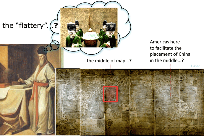 The flattery scenario for explaning the unique shift of the Americas by Ricci in the east part of his map instead of keeping the stereotype placement in the west part as it is the case in all maps of the period
Here, an attempt is made to go beyond the simplistic flattery scenario on Matteo Ricci's cartographic choices. In contrast to the flattery scenario, or to the technical scenario, which after all is a logical interpretative possibility, a cultural scenario is elaborated based on the Greek-Roman geographic and cartographic legacy related to Ptolemaean Geographia and on the Christian doctrines for the depiction of the Orbis Terrarum on maps as exercised in Europe during the Middle Ages. Both cartographic representation
legacies, the Greek-Roman and the Christian, are dominant in the cultural and scientific thinking of Rome at the times of Matteo Ricci who was deeply belonged to this tradition.
Arguments for a cultural scenario
The arguments for a cultural scenario, thus a “flattery-free” approach, about the Ricci's choices for the placement of the Americas and generally for the overall conception of his World Map are based on the hypothesis that Ricci’s geographic education on Greek-Roman geographic and cartographic legacy combined with the culture of Christian depictions of the World in the Middle Ages, was well reflected in his cartographic thinking due to the dominant geography doctrines in Rome. Ptolemaean views of the (Old) World and the Universe was the official line of the Church and of course reflected in Clavius’ teaching at the Collegio Romano, where Ricci, as it is known, was educated in the relevant disciplines
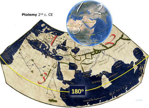 |
Ptolemaean representation of the World (here in Ptolemy first-projection) extended in 180 degrees eastwards (from the Fortunate Isl. to China) representing the three parts of the Old World which cover entirely a terrestrial Globe hemisphere. This model of the World belongs to the Greek-Roman geographic tradition to the Age of Discoveries |
The perception of Ptolemaean description of the Earth was deeply founded in the Roman Church, remembering here that the Atlantic cartographic schools in Europe were gradually reforming the Ptolemaean model and had already moved away from the cultural influence of the Roman Church. The Ricci World Map is cartographically set in the Ptolemaean order as far as the Old World is concerned (Europe, Asia and Africa): it is extended 180 degrees eastwards with the zero meridian at the west-end of the known world, passing from the Fortunate Isles (Canary Isl.). The Ricci map in its Old World representation is typologically relevant
to the Ptolemaean maps based on Geographia. In this context, China is placed according to Ptolemy’s mathematical order at the east-end of the Old Word, which cartographically speaking is not at all at the centre of Ricci’s map as it is after all evident
 |
The Ricci's map follows the Ptolemy eastwards model concerning the setting of the Old World (here the Ptolemy map is in his second-projection) extended in 180 degrees eastwards (from the Fortunate Isl. to China) representing the three parts of the Old World which cover entirely a terrestrial Globe hemisphere |
The placement of the New World (the Americas) East, is in line with the traditional logic of the eastwards expansion of the new geographic knowledge, typical in the evolution of the post-Miletian Greek and Greek-Roman geographic thinking and praxis (Herodotus, Dichaearchus, Alexander the Great, Eratosthenes, Ptolemy)
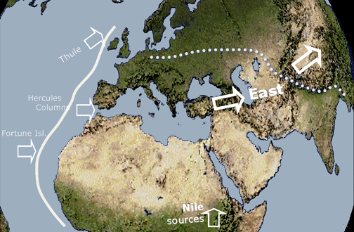 |
The model of the Ancient Greek traditional conception of the expansion of geographic knowledge was always to the East. The geographic barrier was the "end of the World" westwards, so why the zero meridian was at the Fortunate Isl. For the Greeks, the geographic horizon was widening eastwards |
The East direction was also privileged in the European Christian culture of the Middle Ages’ symbolic cartography, starting from the late Greek-Roman period of Ptolemaean Geographia to the Ages of Humanism and of Discoveries, when Ptolemaean Geographia reemerged strongly conditioning the early 15th century European geographic thinking. The Christian circular depictions of the Old World in the Middle Ages are all oriented to the East, heading upwards, to the believed direction of Paradise. Consequently, it is full of symbolism the privileged placement of Asia in the entire upper (eastwards) semi-circle of the Old World, in contrast to the placement of the other two continents in the lower (westwards) two quadrants: Europe in the left (northwards) and Africa in the right (southwards) separated by the Mediterranean Sea
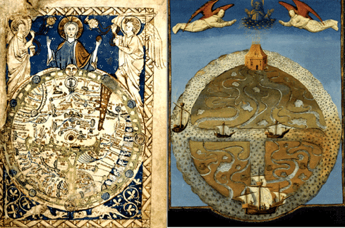 |
The privileged East in the European Christian legacy: two representative circular depictions of the Old World from the High (left; the well known Psalter map) and Late (right) Middle Ages. The entire upper semi-circle represents Asia, the East direction upwards; the lower two quadrants represent Europe (left/northwards) and Africa (right/southwards), separated by the Mediterranean Sea. The Paradise is at the East-end of the map on the top with strong symbolic decoration |
In these circular (or circular-like) depictions the centre is obviously located also on the Asian Continent, in Jerusalem, in the way the very relevant circular Greek depictions of the 7th-5th cent. BCE Miletians (Anaximandros, Ecataeos) represented the three known continents, are centered at the sacred island of Delos in the centre of the Cyclades archipelago at the Aegean Sea
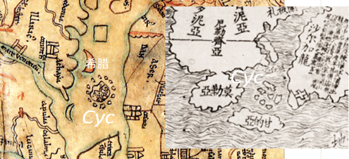 |
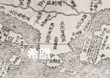
The similarity of the circular pattern representation of the Cyclades archipelago (Cyc) in the Aegean Sea in the centre of the Henry of Meinz 12th cent. map (left; Sawley map) with the relevant shape representation in the Matteo Ricci map (right). This detail in the Ricci map reflects the legacy of some medieval representations to centre the map in the sacred Delos isl. instead of the sacred Christian city of Jerusalem |
In the contexts presented above, namely the Greek-Roman Ptolemaean standard for the measurement of the 0 to 180 degrees width of the known World (the Old World) always and only eastwards, combined with the geographic doctrine of the Middle Ages Christian cartography, concerning the East direction as the privileged orientation of Paradise beyond Asia, the placement of the Americas forward East in the projected 180 to 360 degrees
hemisphere seems to be an expected choice by a Jesuit priest grown up culturally and scientifically in the Collegio Romano under Clavius. The cultural scenario sounds now reasonable especially when related to important elements of the map content, which call into question the flattering scenario about the mechanistic shift of the Americas from the west part to the east part of the Ricci map. In addition, also some claims that presumes influences from the Atlantic cartographic schools of Europe into Ricci’s World Map
need a revision because the Ricci map belongs rather to Italian cartographic typologies, all reflecting the Ptolemaean Geographia legacy.
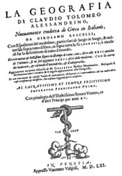 Studying the Pasquale d'Elia 1938 work Il Mappamondo Cinese del P. Matteo Ricci S.I. we see the explicit reference of Ricci's cartography to Ptolemaean Geographia through Gerolamo Ruscelli's works on the Universal Expositions and Introductions over Ptolemaean Geography which is combined in the same volume with Ptolemaean Geographia translated by Ruscelli himself from Greek into Italian (Venice 1561) and used, for certain, in his Chinese cartographic work, as Ricci explicitly states.
Along with the two books of Ruscelli, the same volume also contains a third part, a text by Giuseppe Moleti, the predecessor of Galileo Galilei in the chair of mathematics and astronomy in Padua. It is evident that Ricci certainly used also Moleti's part in the Ruscelli volume on Ptolemaean Geographia in transferring to China as it stands, with the same layout and the same figures from the table of reduction the degrees and minitues of the parallel circles. Given the Ruscelli reference to Ptolemaean description of the cartographic representation through the projection-graticule of meridians and parallels and the positioning of places with a pair of geographical (spherical) coordinates listed in the Geographia volume, it was easy for Ricci to design maps due to his relevant preparation and skills gained in the Collegio Romano. Here, it is important to recall and stress the affinities of the Ruscelli's edition of Ptolemaean Geographia with the almost a decade earlier Giacomo Gastaldi's innovative Geographia edition with a particular care for the representation of the Americas
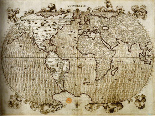 |
The Giacomo Gastaldi World Map, 1546. His Ptolemaean Geographia edition is directly reflected into 1561 Gerolamo Ruscelli's edition of Ptolemaean Geographia, used by Matteo Ricci |
The map shape and content tracks
The discussion on the Ptolemaean influence and east-placement of the New World apart, principal issues concerning Ricci's 1602 copy, of main interest here, are:
- the typology of map projection
- the (claimed) relation with the Atlantic schools of European cartography vs the relation with older Mediteranean (Italian) counterparts of Ptolemaean
- the representation of China
- the representation of Europe, and
- the shape of the representation of the Americas, focusing on the southern part
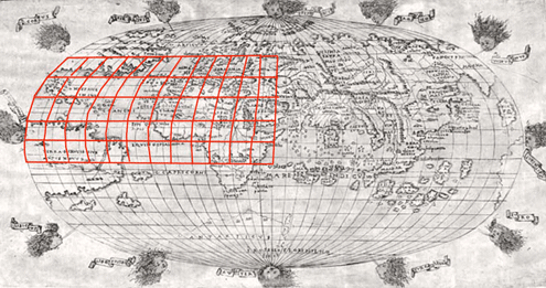
The map projection is obviously of the oval type, with the parallels streight lines and the meridians curvilinear. Oldest type of this projection is first identified in the Contarini-Rosselli World Map of 1508. This projection has a 4th order polynomial transformational relation with the second Ptomely's projection (the curvilinear)
 |
|
The projection was used after, by a series of Italian cartographers in the first half of 16th century, mainly Venetians, i.e. Bordone (1528), Agnese (1540) and Gastaldi (1546) whose cartographic work is transferred in Ruscelli's Ptolemaean Geography (1561) the Ricci's reference volume in China, according to Pasquale d'Elia's documentation. The same oval projection is used later by Ortelius in his Theatrum (1570) provoking thus the idea of a Ricci's track in the Atlantic school of European cartography, which is doubted because of the already existance of relevant Italian maps three quarters of a century earlier than the Ortelius map. The Italian maps in this very projection and in Ptolemaean embedment were familiar to Ricci, whose strong cultural and deep spiritual linkage of the Jesuit priest with the traditionem Romanum kept him oriented to domestic map products and the evident differences of his map compared to the map by the famous Flemish cartographer strongly contest the Atlantic track
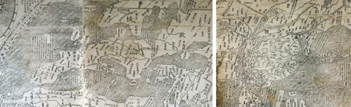 |
The evident spatial information density difference in the representation of Europe (left) and China (right) in the 1602 Matteo Ricci’s WM |
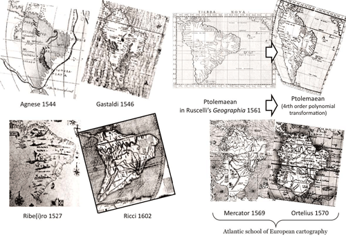 |
Models of the South America shape in examples of the Atlantic school of European cartography and of the Mediterranean counterpart. It is clear that the shape of Ricci’s 1602 coastline resembles the second |
![]()
The page is under development