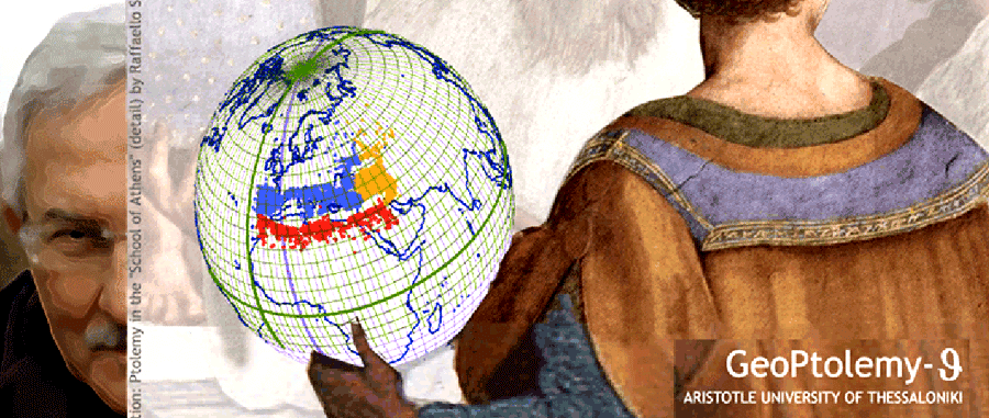


Ptolemy+
The project developed in SRSE - AUTH since the late 1980s and early 1990s, concerning the study, the analysis and the interpretation of the numerical part of Ptolemy's Geographia led to a series of research results, to relevant publications, to a doctoral dissertation in 2011 and to the setting of a new list of coordinates (spherical longitude and latitude) the so-called Thessaloniki Catalogue GeoPtolemy-![]() . This new Catalogue focuses on the areas of the
. This new Catalogue focuses on the areas of the
- Mediterranean
- Greece with the Aeagean Sea
- Black Sea
with the adjacent regions around for a total of 3,825 named and georeferenced places processed
Geographia legacy
Ptolemy wrote Geographia in Alexandia, the 2nd cent. CE. It reappered after almost ten centuries in Constantinople thanks to Maximus Planudes who gave life and maps to the Ptolemy's text. Since then Geographia followed a long road in the European Renaissance from the late 14th - early 15th cent., under the initiative of Emmanuel Chrysoloras. The real expoit in 16th cent. established Ptolemy's Geographia as the highlight of cartographic thinking, introducing the concept of positioning with coordinates, with respect to a relevant reference system of orthogonally intersecting meridians and parallels. Ptolemy is behind the great works of prominent cartographers of 16th cent. like, e.g. Waldseemüller, Münster, Mercator, Ortelius, just to mention few of them among many others more or less known from all over Europe who were in front or behind the publication of the printed editions of Geographia during the Renaissance
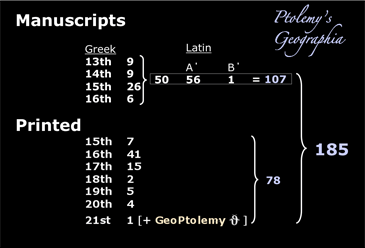
During seven centuries of European cartographic history, from 13th cent. onwards, Geographia appeared either in manuscript or in printed form in 185 versions, mainly in Greek and in Latin (cf. Tsorlini)
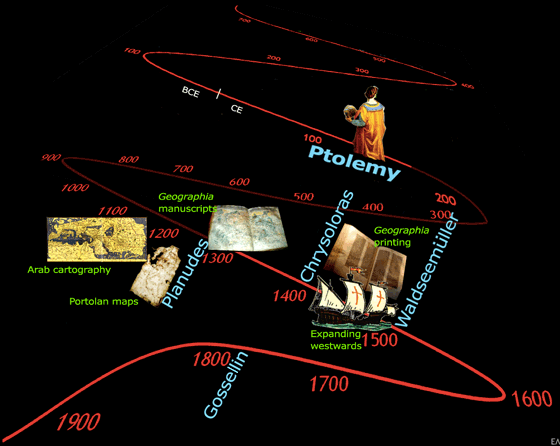
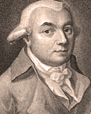
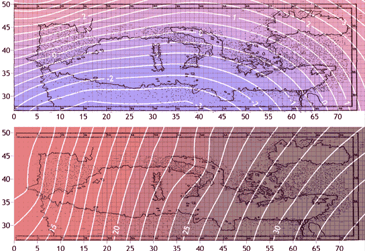
In the course of centuries Geographia attracts the interest of scolars and cartographers, keeping alive its legacy until the late 18th cent. when the geographer P-F-J Gossellin [w(fr)] revisited the Ptolemy's text and especially the numerical part of it [w(fr)] in order to point out, him first in 1790, the discrepancies in longitudes, indicating a method of reduction to proper longitude values (i.e. 700 stadia per degree)
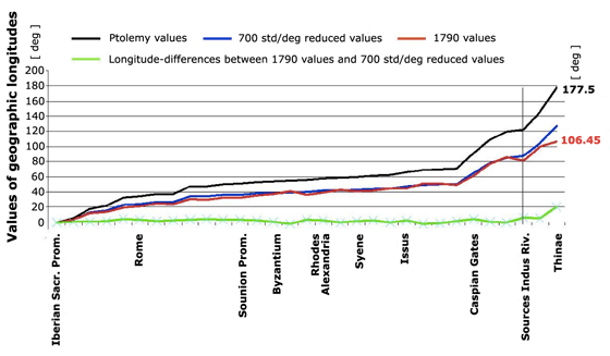 The diagramme illustrating the Gossellin's reduction of Ptolemy's longitudes, considering the length-value of 700 stadia/degree
 The impact of Ptolemy's Geographia is penetrating with increasing density the course of the centuries from the late Middle Ages to the twilight of 18th cent. In the last years of our digital era, the revival of the interest for Geographia numerical part is more than evident
In recent years the interest on Ptolemy's Geographia numerics seems to open a new field of research thanks to digital approches and the relevant digital tools abundantly available in such types of research in the context of Cartographic Heritage
GeoPtolemy/theta
Research on Geographia's numerical part at Thessaloniki started the end of 1980s in the frame of a dissertation by the late M. Valsamaki. The focus in that early research on Ptolemy's numerical values was concentrated mainly on the longitude problem and the relevant positiong of places with the associated toponymy at the area of Greece. Empirical statistical models developed at that time fueling the interest to approach the Ptolemy's lists of spherical coordinates in a more technical manner. The efforts on this project intensified in the mid 2000s working now systematically on the issue, in the context of Cartographic Heritage, the newly established ICA initiative at that time. Angeliki Tsorlini runned the project supervised by C. Boutoura and E. Livieratos, focusing on the entire Meditteranea area, including Iberia, Italy, Greece, Asia Minor with the Black Sea and the north coasts of Africa (for an extended summary in Engish)
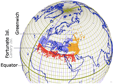
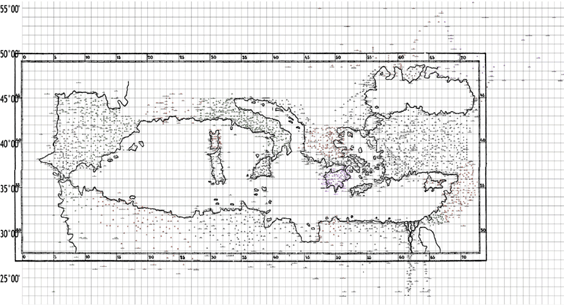
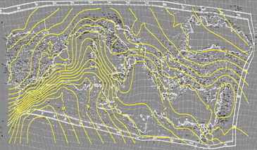
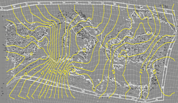
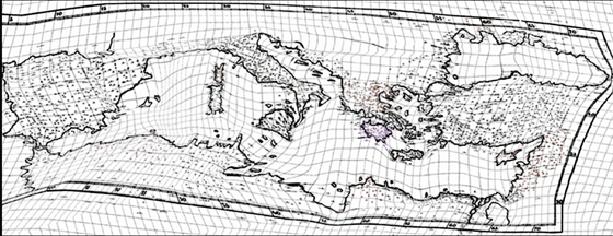
The 3,825 places determined around the Meditteranean, including Iberia, South France, Italy, South-East Europe, Asia Minor and the North African coasts
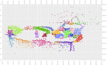
The 3,825 places coloured according the region they belong in the relevant Geographia-Table; cf. >
The core
The core of this research is the setting of a new catalogue of consistent place-coordinates derived from an exaustive comparative analysis of nineteen versions of Ptolemy's Geographia (4 manuscripts and 15 printed) starting from the 13th cent. Vaticanus Urbinas Gr. 82 to the 2006 Berne-Basel Handbuch der Cartographie
The 3,825 places, as derived by the auto/cross checking control applied to the 19 Geographia versions are listed in the data-base followed by:
- the region they belong according to Ptolemy classification
- the code number within the data-base
- the name and the place description in four languages (according to the relevant languages of the Geographia versions) i.e. Greek, Latin, Italian and English
- the uniquely defined geographic coordinates in degrees and primes

Having done this huge work the new coordinates offer the material for a series of further analyses on the geometric spatial properties of Ptolemy's Geographia for the focused area offering new insights on the issue. New research topics open now, as e.g.
- the study of coordinate differences between various Geographia versions
- the relation of the given coordinates with the derived relevant maps
- the evaluation of the Geographia-born cartography and classes maps
- the comparison of maps derived from different Geographia versions
- the comparison of Geographia coordinate-values with their present-day values allowing the extraction and modelling of spatial trend-patterns of systematic differences
- the spatial deformation analyses of the residuals after the filtering-out of the systematic trends
References
A. Tsorlini, M. Pazarli, N. Ploutoglou, C. Boutoura, E. Livieratos 2011, "A digital referenced study of Pierre Lapie's maps of Greece (1822, 1826) with respect to his cartographic reconstruction of Ptolemy's Geographia (1834)", Proceedings, 25th International Cartographic Conference, July 3-8, Paris, France
A. Brychtová, A. Tsorlini 2010, "Differences of Ptolemy based cartography of Central Europe with respect to recent Czech Republic representations", e-Perimetron, Vol. 6, No. 2, 96-113
A. Tsorlini 2009, "Spatial distribution of Ptolemy’s Geographia coordinate differences in North Mediterranean eliminating systematic effects", ICA 4th International Workshop Digital Approaches to Cartographic Heritage, Venice, Italy, April 6-7. Also in e-Perimetron, Vol. 4, No. 4, 247-266
A. Tsorlini 2008, "Higher order systematic effect in Ptolemy's Geographia coordinates description of Iberia", ICA 3rd International Workshop Digital Approaches to Cartographic Heritage, Barcelona, Spain, June 26-27. Also in e-Perimetron, Vol. 4, No. 2, 117-130, (2009)
E. Livieratos, A. Tsorlini, C. Boutoura, M. Manoledakis 2008, "Ptolemy’s 'Geographia' in digits", e-Perimetron, Vol. 3, No. 1, pp. 22-39
M. Manoledakis, E. Livieratos 2007, "On the digital placement of Aegae, the first capital of ancient Macedonia, according to Ptolemy's Geographia", e- Perimetron, Vol. 2, No. 1, 31-41
A. Tsorlini, E. Manoledakis, C. Boutoura, E. Livieratos 2007, "Thessaloniki Project on Ptolemy’s Geographia", 22nd ICHC - International Conference on the History of Cartography, Berne, Switzerland, July 8-13
A. Tsorlini, E. Livieratos 2007, "Digital Approaches in eliminating the higher order systematic effects in Ptolemy's 'Geographia' longitude and latitude differences", Presented at the 23rd International Cartographic Conference, Moscow, August 4-10
E. Livieratos, A. Tsorlini, C. Boutoura 2006, "Coordinate analysis of Ptolemy’s Geographia Europe Tabula X with respect to geographic graticule and point positioning in a Ptolemaic late 15th century map, Proceedings, ICA - 1st International Workshop Digital Approaches to Cartographic Heritage, Thessaloniki, May 18–19. Also in e-Perimetron, Vol. 2, No. 2, pp. 80-91 (2007)
Livieratos E. 2006, "Graticule versus point positioning in Ptolemy cartographies", e-Perimetron, Vol. 1, No. 1, 51-59
E. Livieratos 2006, "On the study of the geometric properties of historical cartographic representations", Cartographica, 41 (2), 165-175
E. Livieratos 2004: "On some cartographic representations of the insular components of the Adriatic - Ionian sea"; in Adrionian extrema - proxima. From an ancient sea to a modern network: Visions, echos, maps and routes, E. Beriatos & E. Livieratos (eds), Thessaloniki: National Centre for Maps & Cartographic Heritage / Aristotle University of Thessaloniki; Argostoli: Cephalonia-Ithaca Foundation
E. Livieratos, M. Valsamaki, C. Boutoura, E. Farantaki, M. Asteriadou 1995, "Cartometric Analysis of Ptolemy's Maps of Greece". Poster presentation at the 16th ICHC - International Conference on the History of Cartography, Vienna, Austria